

A draft Narrabri flood study which has been placed on extended public display is recommending several mitigation measures.
Among the recommendations in the draft Narrabri Floodplain Risk Management Study and Plan are significant zoning changes and building considerations for new developments.
Voluntary house purchasing and house raising options to be made available to eligible residents in the most at-risk areas forms part of the mitigation measures.


Further analysis of channel widening and levee schemes for Horsearm and Mulgate Creeks as well as the investigation of suitable sites for new evacuation centres is also part of the recently released draft plan.
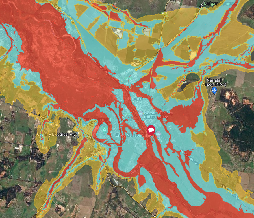
Areas surrounding creeks and rivers (as detailed on the map on page three of today’s Courier) are deemed a high risk.
No filling or residential/commercial development of any kind would be allowed in the high risk zone.
All future development would be prohibited as part of the plan. Undeveloped land within the floodway, mostly along Mulgate Creek adjacent to industrial land, would be rezoned.
In the high risk zone, possible participation in the voluntary purchasing scheme for existing residential properties which meet the NSW Department of Planning and Environment criteria forms part of the mitigation strategy.
Changes will also be made to the medium risk zone which takes in all of the Narrabri town area, the village and parts of Narrabri West. Part of Narrabri West has also been deemed a low risk area.
The medium risk area, which covers much of Narrabri, includes the same measures as a low flood zone.
Prohibiting land use intensification (i.e. subdivision, construction of additional habitable residential structures on already developed lots), forms part of the mitigation strategy.
Prohibiting development for which assisted evacuation would be required (aged care and some medical facilities) is also among the recommendations.
Other measures in the medium risk zone include: All new habitable residential buildings, and extensions of existing habitable residential buildings be required to prepare a flood evacuation plan; new habitable buildings to have access to an emergency evacuation centre; commercial buildings will require a flood management plan; possible participation in the voluntary house raising scheme for existing residential properties which meet the NSW Department of Planning and Environment criteria.
Residental property owners in the low risk area will see almost no change to how they may develop their property.
Floor levels for new commercial properties to be one per cent annual exceedance probability (1-in-100 year flood) is part of the proposed controls.
Also included in the controls is: Flood impact assessment required for excessive fill (over and above current Development Control Plan requirements); residential foundation controls below flood level; minor extension floor levels not less than the existing habitable floor height (level); hazardous materials be prohibited at levels below the flood planning level in all circumstances, unless suitably bunded – for example, service stations.
A number of structural options to mitigate flooding in Narrabri has also formed part of the plan.
The only viable structural option identified was to undertake a further analysis of channel widening and levee schemes for Horsearm and Mulgate Creeks.
A key priority identified as part of the plan is to identify suitable emergency evacuation sites that can be easily accessible and not prone to flooding.
Continued devastating national rainfall patterns, plus a NSW government funded requirement, means community members have the opportunity to have their say on the proposed study and plan.
Under the NSW government’s Floodplain Management Program, Narrabri Shire Council was funded, and engaged WRM Water & Environment to prepare the Narrabri Floodplain Risk Management Study and Plan.
Scientific (hydrologic and hydraulic) investigation of flooding including to existing waterways and drainage areas and existing land use and zoning areas resulting from Narrabri and surrounds rainfall events – plus data collection and existing data – produced the modelling for the study and plan.
Mayor Ron Campbell said in defining the nature and extent of flooding in Narrabri, the plan also includes the impacts of social, ecological and economic factors.
The document contains varying priorities, from high to low, with the highest being to develop and implement an ongoing flood education plan, consult with properties currently identified for voluntary purchase as well as applying for state government funding. Horsearm Creek mitigation is also a high priority.
The plan has also highlighted the current sites deemed as evacuation centres. These include the Narrabri RSL, The Crossing Theatre, Narrabri Public School and Narrabri West Public School.
However, the report noted these sites are each within flood risk areas and are flood affected to varying degrees. It did point out that these sites are generally resilient to above floor level flooding.
The obvious site for an evacuation centre was at Narrabri West, the report noted.
However, currently no buildings are large enough in the low risk zone. The area is also potentially inaccessible for the population in the eastern parts of town.
“It is recommended to consider entering an arrangement with a commercial operation that has a large shed that could be retrofitted for emergency accommodation,” the report read.
Due to the importance of the plan, council said it would be on public exhibition until Monday, November 28.
This week, council will be holding community information sessions from Tuesday to Thursday on the Narrabri Floodplain Risk Management Study and Plan at The Crossing Theatre and the Narrabri Aquatic Centre multi-purpose room, where people can find out more information about the draft study and plan.
As previously advertised in The Courier, an information session will be held at The Crossing Theatre tonight, Tuesday, from 6.30-7.30pm.
An early morning session will be held on Wednesday morning at the aquatic centre multi-purpose room from 6.30-8am, followed by a drop-in session at the Maitland Street kiosk from 12-2pm and then again at The Crossing Theatre from 6.30-7.30pm.
An early morning session will also be held on Thursday morning, at the aquatic centre from 6.30-8am.
At these sessions, a representative from the organisation engaged to undertake the study and plan – WRM Water & Environment will be in attendance.
Those unable to attend the information sessions can access the meeting via Zoom, they must register to do so.
The two morning information events are breakfast sessions being held for businesses and for any other community members who wish to attend.
For further information on the Narrabri Floodplain Risk Management Study and Plan, including proposed planning measures, people can contact council or see the details on its website. To register your attendance at one of the information sessions, contact council on 6799 6866 or register on council’s website.
To order photos from this page click here