
There are concerns the Glencoe height gauge on the Namoi River is providing “inaccurate” readings relative to historic heights, causing misinformation and uncertainty in the community and WaterNSW is being asked to rectify the issue.
Wee Waa farmer Daniel Kahl said the Glencoe gauge was relocated to a new site about three years ago to allow safer access for Water NSW staff as the bank at the old site was deemed too steep.
“The misinformation it’s causing is ridiculous,” he said. “People know that the ‘84 flood was the record at 7.52 metres and that (levee) banks are now built to handle that, plus some.


“The gauge is currently (Sunday) reading 7.4 metres and it’s making people nervous because they don’t know that really, it’s at 7.18m relative to historic heights.”
“If this is not corrected soon, we’ll continue to see this inaccurate data recorded and accepted as truth, which plays into how floods are managed here. The flood in November last year reached 7.55m on the new gauge, which would be the highest ever but in truth it wasn’t. Relative to the historic heights, it was 7.33m.”
“It’s really important this is fixed and that more than 60 years of river data is made irrelevant by ignoring the fact that the new meter doesn’t provide an accurate reading of flood behaviour.”
Mr Kahl has informed WaterNSW about his concerns and through Member for Barwon Roy Butler has also recently urged the NSW government to address the issue as Wee Waa has faced road closures based on the heights, impacting local business, workers who travel in and out of the levee and operations of services such as schools.
“There is a detailed knowledge of the river and flooding in the local community that is based on the historical numbers of the old gauge.
“That knowledge feeds into local authorities’ decision-making around emergency services, road closures and directly impacts people’s livelihoods, incomes, and the local economy, as well as the welfare and peace of mind of residents in Wee Waa and surrounding properties.”
Mr Kahl has shared his letter of explanation about the river gauge with The Courier:
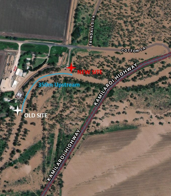
Approximately three years ago, the Wee Waa (Glencoe) gauge was relocated to a new site to allow safer access for Water NSW staff, as the bank at the old site was rightly deemed too steep.
The site moved 350m upstream and was surveyed and levelled in an attempt to ensure it would read at the same heights. The below list describes the behaviour of floods based on heights from the old gauge. The numbers correspond with the locations marked on the map, pictured below.
Location 1
5.5m – Floodwater enters the Myall Vale Channels and may run under the bridges on the Kamilaroi Highway.
Location 2
6.0m – Water from Myall Vale Channels reaches the first causeway (from the southern end) of Trindalls Lane.
Location 3
6.1m – Water from the river may reach the causeway on the Kamilaroi Highway one kilometre west of Myall Vale bridges and could cross the road.
Location 4
6.2m – Water may cross the second causeway on Trindalls Lane, potentially flowing north-west towards Tulladunna and Doreen Lanes.
Location 5
6.3m – Water may cross the Kamilaroi Highway at Glencoe Channel. Expect to see water on the road.
6.4m MODERATE FLOOD LEVEL
– Water starts to encroach all access roads into Wee Waa.
Location 6
6.7m MAJOR FLOOD LEVEL
– Road access to Wee Waa for all but high clearance vehicles is lost. (Source: Discussion paper – NSW SES Community Meeting 16/12/2013)
– Water may cross the third causeway on Trindalls Lane, flowing north-west towards Boolcarrol/Spring Plains Rd.
What has not been factored in whilst setting up the new site is the difference in heights due to the slope of flood water when the river is high.
The new site experiences a build-up of head as flood water builds up (particularly in the area shaded red), attempting to find the path of least resistance and eventually flowing away from the area via the river or the network of floodways on the Lower Namoi Floodplain (orange arrows).
From 5.5m, water has been following the path of the Myall Vale Channels (1), which until reaching 6.0m, returns to the river (the blue line).
From 6.1m, water begins to break out of the river and flow north west (green arrows) under and eventually across the Kamilaroi Highway (3).
Between 6.0m and 6.2m, the build-up of water in the red zone reaches heights that cross Trindalls Lane (2 and 4) and begins to flow down the floodways to the west.
At 6.3m the river pushes water across the Kamilaroi Highway at Glencoe channel (5).
From 6.7m, the build-up of head beyond the red zone pushes water north and crosses Trindalls Lane at the third causeway (6).
The old gauge site was not impacted by this build-up of head in the red zone.
It was/is located back within the river channel where the water now picks up speed again and falls away having chosen its path.

The numbers on this map correspond with the location list in the letter, detailed above.
Below are some examples of this from both the November 2021 and September 2022 floods.

On the left is the old gauge site, reading 7.24m. On the right is the new gauge site reading 7.46m. Both sites were recorded on the November 29, 2021, approximately five minutes apart (the time to walk between the two).

On the left is the old gauge site, reading 7.04m. On the right is the new gauge site reading 7.25m. Both sites were recorded on September 28, 2022, approximately five minutes apart
The difference between the two sites at major floods levels is consistently 20-22 centimetres higher at the new gauge.
The effect of the build-up of head and the fall of the flood slope between sites can be seen by the rapid movement of water in the background of the images of the old gauge as it falls down the slope once back within the river channel, compared to the flatter, slower moving water in the background of the images of the new gauge as the water builds up to choose its path.
It is not possible to provide evidence of this impact below 7.0m because in decommissioning the old site, the measurement markers were removed despite the request by the landholder to WaterNSW staff leave them as a point of reference for this very reason.
It is not satisfactory that this difference is accepted and ignored.
It is also not satisfactory that WaterNSW pass the buck on to the Bureau of Meteorology and request them to adjust the flood heights for Wee Waa, as I understand has been done. There is a detailed knowledge of the river and flooding in the local community that is based on the historical numbers of the old gauge. That knowledge feeds into local authorities’ decision making around emergency services, road closures and directly impacts people’s livelihoods, incomes, and the local economy, as well as the welfare and piece of minds of residents in Wee Waa and surrounding properties.
A proper hydrological assessment needs to be done to properly assess the behaviour of the river heights at the two sites, from an empty river all the way to a major flood, to allow for a recalibration of the new gauge to accurately match the old gauge that it replaced. If not, then the gauge should be relocated back to the same point in the river. If the northern bank is too steep, then it should be installed on the southern bank (the lower bank which is not as steep) and the meter installed on a stand above flood height to protect it.
Daniel Kahl
Merced Farming Pty Ltd
To order photos from this page click here