

There are many opinions, anecdotes and lived experiences to draw on when people talk about floods in the Namoi Valley.
A few truisms emerge – we have had many floods, there will be more and no floods are the same.
A range of self-evident factors come into play when the big rains fall and a flood gets underway – when and where it rains in the valley, the ground cover at the time, the impediments, buildings and other structures in the way of the water and other variables.


People turn to government agencies and emergency services for definitive answers, but the nature of nature means that absolute answers are not always available before the fact.
However, there is a considerable body of scientific knowledge and local experience which allows a high degree of predictive certainty around potential flood heights.
What does it mean when flood heights are quoted at Narrabri?
Narrabri-based water engineer Jim Purcell is one scientist who has a keen professional and local interest in flood behaviour.
“We are trying to explain a detailed picture in a simple way,” commented Mr Purcell.
“But it’s quite a complex science.”
We can start with the basics.
Flood readings, the depth of water above the bed of the creek, in broad terms, are taken every 15 minutes and are averaged for the day.
“In 132 years, from 1890 to now, there have been 45 Narrabri Creek floods,” Mr Purcell said.
“Of the 45, 25 were classed as major, two were ‘moderate’, and 18 were ‘minor’ according to the levels reached.
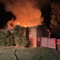
“A ‘major flood’ definition used by SES and Water NSW is higher than 6.7 metres – and we just had 7.6 metres peak.
“It is not considered a ‘flood’ until it reaches 4.9 metres at Narrabri.
“In 1984, the gauge recorded 8.3 metres at Narrabri.
“The previous most recent major flood was in November 2021, 7.3 to 7.5 metres.
“Our October 2022 flood was 7.6 metres, so they are very similar floods. This flood has stayed longer because everything downstream was full.
“The 1955 inundation, close to a one-in-100 year flood, was 9.4 metres, so was the 1910 flood.
“In 1998, it was 8.2 metres – we had seven peaks in that flood.”
This year heavy rain fell for a long time, right across eastern Australia.
“On Saturday, October 22, the Namoi at Manilla was flowing at 213,000 megalitres per day,” said Mr Purcell.
“That volume would be enough to fill Keepit Dam, from empty to full, in just two days.
“On the same day, they were releasing 101,000 megalitres per day from Keepit. That’s what was heading to Narrabri and Gunnedah.
“So Keepit was still being used as a bit of a buffer, which is normal.
But as soon as the flow to Keepit dropped, they brought the dam back down to a safe level.
You can’t run every dam at 100 per cent because you may get a massive storm, so most dams have an emergency spillway. There are operating instructions at Keepit to manage this, it’s quite complex.
“They were sobering numbers on the Saturday,” Mr Purcell added.
“But that doesn’t mean we are going to get 100,000 megalitres which will immediately turn up at Gunnedah.
“On the same day, the Namoi at Gunnedah was flowing at 55,000 megalitres per day.
“That meant it was filling up the floodplain again.
“For instance, I got a worried phone call that 213,000 megs was coming from Manilla. The peak flow at Narrabri in 1984 was 222,000 megalitres per day. It’s not that simple. A flow of 213,000 megalitres per day at Manilla is not 213,000 megs/day at Narrabri.
“Another furphy is that since we have Keepit and Split Rock Dams, we will not have a big flood again, but this dispels that.
“The dam was empty and in two days could be full and overflowing.”
Every flood is different – it all has to do with timing.
The old analogy of the tumblers on a poker machine describes it best – if all the icons line up at the same time, there is a problem.
“For example, if the flood peak from Cox’s Creek and Gunnedah and Mulgate Creek and Maules Creek all arrive at Narrabri at the same time, we have a very large flood – and that’s what happened in 1955,” Mr Purcell said.
To order photos from this page click here