
Why we should remember our history of flooding
It would be fair to say that in the first two decades of this century the occurrence of major flooding has not been in the forefront of the minds of most members of the Narrabri district but some parts of the Namoi River system have experienced periods of flood disruption.
Rather, the main focus of concerns about the climate and the environment in this area has tended to be more on the question of a lack of rain, rather than an overabundance of rain. In more recent years the dangers and costs imposed by moderate or serious flooding in NSW and the eastern states in general have become more apparent as evidence mounts that the consequences of global climate change include serious economic and social harm.
It is very clear now that our society and our governments at all levels must assume that the decades ahead may bring more – not less – adverse climate-related consequences.


We should not forget, however, that the effects of climate extremes in Australia are not new.
While we should prepare for a more uncertain future weather-wise it may be useful to revisit some of the historic experiences with flood events.
The loss of widespread knowledge in the broader community about flood events in the past and the statistical potential for floods in the future is something that is a cause for concern about those who make it their job to prepare for floods – of all sizes.
The Courier’s own files and other sources reveal that previous generations have recorded the effects of serious flooding and speculated on the question of climate variability.
The benchmark flood
The benchmark flood for Narrabri district (and many other areas) has been the one-in-one hundred year event which occurred in late February 1955.
Since that time Narrabri and district has experienced a range of lesser flood events, some quite serious, but the odds are mounting in favour of another ‘big’ flood as the decades roll on.
The recent flooding experiences of some centres in NSW suggest that we may have to expect that historic record flood levels have been far exceeded.
Even if the impacts of global warming on climate change are ignored (that is, the likelihood that we will experience wetter ‘wet’ periods and dryer ‘dry’ periods) recent scientific studies by a Newcastle university researcher in conjunction with other investigators studying ice core data from Antarctica suggest that in the past 1000 years NSW has experienced some big swings in climate patterns. The researcher, Dr Anthony Kiem, said the new data gives a longer baseline for both drought and wet periods. The findings offer a new perspective on what we may have thought about extremes from contemporary weather records.
Contemporary records show that droughts can run for about eight years at maximum and wet periods last over seven or eight years but the 1000 year snapshot shows that wet extremes can last for up to 39 years and droughts for as long as 12 or 13 years.
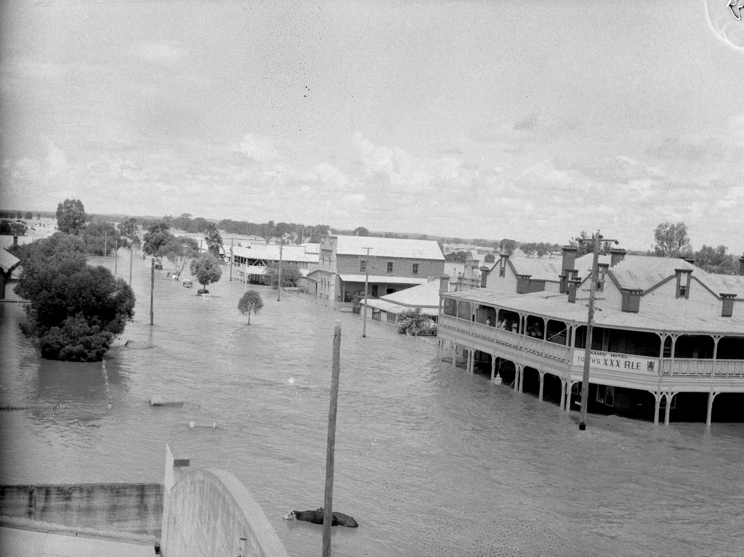
On February 27, 1955, the record flood in the 20th century peaked in the Narrabri Creek at 9.44m. Hundreds of homes and businesses were flooded and many families were forced to climb on to their rooftops to escape the rapidly rising water. The costs imposed on towns and district were enormous.
However, our contemporary records show that the district has known some big floods in historic times.
Even allowing for the movement of gauges, possible inaccuracies, and changing patterns there is no doubt that the 1864 flood in the Namoi Valley was king-size; a one-in-100 year event.
The lack of recording stations at that time make it difficult to assess the real magnitude of the 1864 event but the reading at Gunnedah was 9.83m (compared to 9.6m in 1955) and the height at Wee Waa was also 9.83m (compared to 9.7m in 1955).
Since 1955 the Narrabri district has experienced significant floods (or floods that threatened to be significant) in 1962, 1964, 1971, 1976,1984, 1998 and 2000. There have been, of course, minor events in between which have put the low level Violet Street bridge under and flooded parkland in Narrabri.
It is necessary to go back to 1890, 1910, 1908 and 1890 to find floods of a similar magnitude and effect of the 1955 event.
But the historical evidence shows that no two floods are likely to be the same.
The combination of tributaries, rainfall patterns, and human alterations to the landform can lead to different characteristics for each flood.
It follows that it would be foolish to think that every climatic variation and every flood pattern has yet been seen in the Namoi Valley.
In January-February 1984 the Namoi Valley experienced a flood which demonstrated the uncertainties mentioned above.
High levels in the Upper Namoi system caused concern downstream and, based on information from Gunnedah, a peak of 8.1m was predicted for Narrabri (1971 peak was 8.92m).
But, for reasons not fully understood the water passed through Narrabri quickly and the peak on February 2 was some 30cm lower than expected.
Landform changes around Wee Waa, however, saw the flood level rise to a critical point on the Wee Waa levee.
What should have been a moderate flood became a major problem. The resultant concern and agitation led to levee improvements.
The peak recorded at Glencoe was 7.51m. Previous Wee Waa flood readings were taken from Tulladunna.
The ‘strange’ flood of 2000 reached a peak in Narrabri of 7.81m around 11am on Thursday, November 23. This flood was the culmination of weeks of wet weather.
But the peak in Narrabri was about half a metre less than the level anticipated by State Emergency Service officials at the Namoi regional HQ of the SES in Gunnedah. A similar result to the 1971 event.
The reason for the lower-than-expected peak is thought to lie in the fact that cleared river channels and floodways and the removal of obstacles on the river banks allowed water to pass through Narrabri much quicker than in previous floods.
Big floods seem to occur in the summer months but winters, too, can be very wet at times. The 1998 flood was unusual. A long period of wet weather in July, August and September beset the region and generated an unusually long winter flood period which saw life disrupted in the Namoi Valley for months. Narrabri district crops, especially, were ruined and community life disrupted.
In a 1980 report prepared for the Department of Water Resources by Laurie Montgomery and Petit Pty. Ltd. the following warning was made: “If a hierarchy of river valleys with flooding problems was to be established for the state’s inland and coastal rivers, the Namoi Valley would either head the list or be very close to the head. In making this assessment, the consultants are not unfamiliar with flood problems in other inland rivers and on the coast.”
How big, then, could a Namoi Valley flood be?
The worst-case engineering study suggests that the Namoi Valley would be in deep, deep trouble if the tumblers of fate delivered very heavy rain (say 75mm) at roughly the same time over every catchment in the system. Fortunately, the size of the region and the uneven nature of rainfall distribution makes this unlikely – but not improbable.
What about pre-white settlement?
In terms of factual information we are limited to historical records. However, there is anecdotal evidence of some very large floods in the Namoi system. It is necessary to retreat into unsubstantiated pioneer’s tales and Aboriginal legend to speculate on earlier, bigger floods.
An item reported in the Namoi Valley Independent in 1955 and requoted in The Courier said this:
‘According to certain markings which local property owners on the northern side of the river have found the great February flood this year may have only been a “pup” compared with some greater flood. Markings of gravel deposits and silt which were distinct after the 1955 flood receded have their parallel in more ancient markings of exactly the same type at Messrs. Stan Finlay’s and Les Shaw’s properties north of the river.
The difference is that the ancient markings clearly show that the 1955 flood did not extend nearly as far as a flood indicated in earlier days. According to the book Red Chief (by Ion Idriess) a major flood took place in the district at some time in the 1750s and was of such vast dimensions that it gained a place in the legends of the Gun-ne-dah tribe.
Those who speculate about the ‘cycle’ theory of flood events believe the above would indicate a great flood between 1755 and 1765. Written history provides more definite records of major floods in 1864, 1910 and 1955 – all cycles of 40 to 50 years.’
We may be on firmer ground in the 1800’s. The first written account of a flood in the Namoi Valley refers to a flood event in 1840 which allegedly impressed local Aboriginal people because of its size.
The reference, quoted in the 1973 Centenary of Publishing supplement of The Courier, states:
“Great Flood in the Namoi, 13th to 21st January, 1840. During the flood, Lieut. Lowe lost his life. He had been five days in the branches of a tree, exposed to the scorching rays of the sun, and from this exposure he died shortly after. His station was situated on the Namoi River, between Tibbereena and Terryeroo”.
1890 and 1910
The 1890 flood, was by recorded accounts, a savage event which claimed a number of lives.
The flood broke the back of a big drought but also destroyed an almost-completed bridge being built at Walgett by Narrabri contractor John Butler Brake.
In the late 1880s the Namoi had been reduced to a chain of waterholes (1888 was a cruel drought year) but the Barwon and Namoi reportedly came down together “wrecking in one night months of work, and carrying with it plant a stores worth thousands of pounds. It was by the very narrowest of margins that the men employed on this work escaped being swept away by the angry floodwaters, but again by their chief’s knowledge, a site some distance away saved their lives. It was an anxious night, Mr Brake used to tell, watching the waters gradually encroaching the piece of elevated red ridge.”
The 1890 flood was also recalled in 1955 by Mr R. Robinson of Jews Lagoon. He was quoted by The Courier as saying that the March 1890 flood was higher but the ‘55 was as disastrous.
He recalled that a family living at Bullawa Creek was swept away and drowned in 1890. (This would have been Mrs Corr and her daughter).
He claimed that water covered the streets in Narrabri to a depth of four or five feet but, as Narrabri West was the major residential area at the time “not much notice was taken of the area which now constitutes the town,” reported The Courier.
The flood of 1910 caused a considerable amount of damage in Narrabri and caused the destruction of the Narrabri Creek bridge which had stood for 30 years.
The Narrabri Herald reported: “From the mark on the big dead tree at Tarriaro Bridge, we understand the present one came to within six inches of that height (1864 flood level).”
The 1920 flood reached 8.99m on the Narrabri Creek gauge. (It was followed by another rise in August to 5.79m).
This recapitulation of flood events in the Namoi Valley, with its particular reference to the Narrabri Shire, gives a brief outline of the nature of flooding in the region. Younger generations and newcomers to the area may not give much thought to the dangers of a flood event – especially when the passing years are essentially regarded as ‘dry’. But, if we live in an area it is worthwhile knowing that significant adverse events such as flood and bushfires do occur from time to time. When lives and property are at risk at such times it is wise to take heed of the advice of those people who have devoted time and effort to prepare for such eventualities.
To order photos from this page click here